- Data and Research
PARTNER POST: MAAP #40: Early Warning deforestation Alerts in the Peruvian Amazon, Part 1
Aug 18, 2016||3 minutes
Disponible en Español aquí.
GLAD alerts are a powerful new tool to monitor forest loss in the Peruvian Amazon in near real-time. This early warning system, created by the GLAD laboratory at the University of Maryland and supported by Global Forest Watch, was launched in March 2016 as the first Landsat-based (30 meters resolution) forest loss alert system (previous systems were based on lower resolution imagery). The alerts are updated weekly and may be accessed through Global Forest Watch (Image 40a, left panel) or GeoBosques (Image 40a, right panel), a web portal operated by the Peruvian Ministry of Environment.
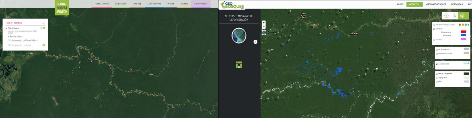 Image 40a. Data: UMD/GLAD, WRI/GFW, PNCB/MINAM
In MAAP, we often combine these alerts with analysis of high-resolution satellite imagery (courtesy of the Planet Ambassador Program and Digital Globe NextView service) to better understand patterns and drivers of deforestation in near real-time. In this article, we highlight 3 examples from across the Peruvian Amazon: Example 1: Logging Roads in central Peru (Ucayali) Example 2: Invasion of Ecotourism Concessions in southern Peru (Madre de Dios) Example 3: Buffer Zone of Cordillera Azul National Park (Loreto).
Example 1: Logging Roads in central Peru (Ucayali)
In the previous MAAP #18, we documented the proliferation of logging roads in the central Peruvian Amazon during 2015. In recent weeks, we have seen the start of rapid new logging road construction for 2016. Image 40b shows the linear forest loss associated with two new logging roads along the Tamaya river in the remote central Peruvian Amazon (Ucayali region). Red indicates the 2016 road construction (35.8 km). Insets A and B indicate the areas shown in the high-resolution zooms below.
 Image 40b. Data: UMD/GLAD, Hansen/UMD/Google/USGS/NASA, MINAGRI
The following images show, in high-resolution, the rapid construction of logging roads in 2016. Image 40c shows the construction of 16.1 km between May (left panel) and July (right panel) 2016 in the area indicated by Inset A. Image 40d shows the construction of 19.7 km between June (left panel) and July (panel right) 2016 in the area indicated by Inset B.
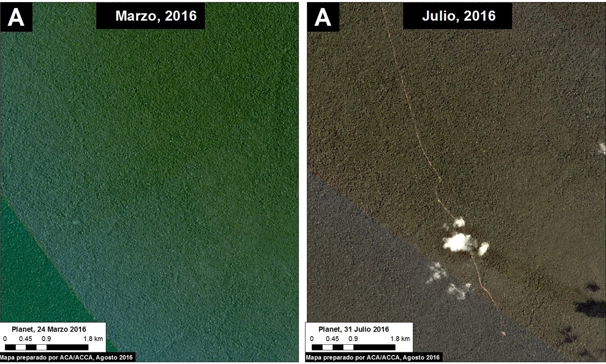 Image 40c. Data: Planet
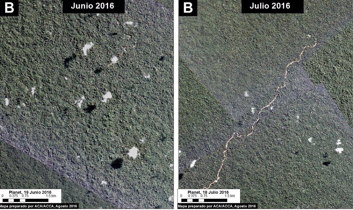 Image 40d. Data: Planet
Example 2: Invasion of Ecotourism Concessions in southern Peru (Madre de Dios)
Image 40e shows the recent deforestation within two ecotourism concessions along the Las Piedras River in the Madre de Dios region. Red indicates the 2016 GLAD alerts (67.3 hectares). Note that the Las Piedras Amazon Center (LPAC) Ecotourism Concession represents an effective barrier against deforestation occurring in the surrounding concessions. In the previous MAAP #23, we indicated that, according to local sources, one of the main drivers of deforestation in the area was the establishment of cacao plantations. Inset A indicates the areas shown in the high-resolution zoom below.
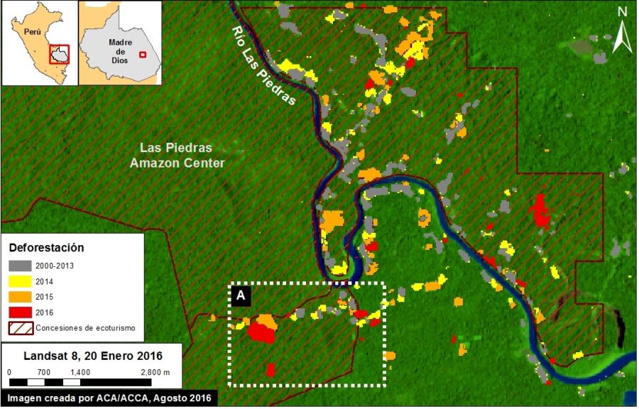 Image 40e. Data: UMD/GLAD, Hansen/UMD/Google/USGS/NASA, MINAGRI
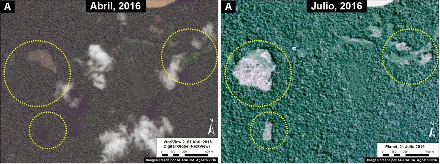
Image 40f shows high-resolution images of the area indicated by Inset A between April (left panel) and July (right panel) 2016. The yellow circles indicate areas of deforestation between these dates.
Image 40f. Data: Planet, DigitalGlobe (Nextview)Example 3: Buffer Zone of Cordillera Azul National Park (Loreto)
Image 40g shows the recent deforestation within the western buffer zone of the Cordillera Azul National Park in the Loreto region. Red indicates the 2016 GLAD alerts (87.3 hectares). It is worth noting that this area is classified as Permanent Production Forest, not as an agricultural area.
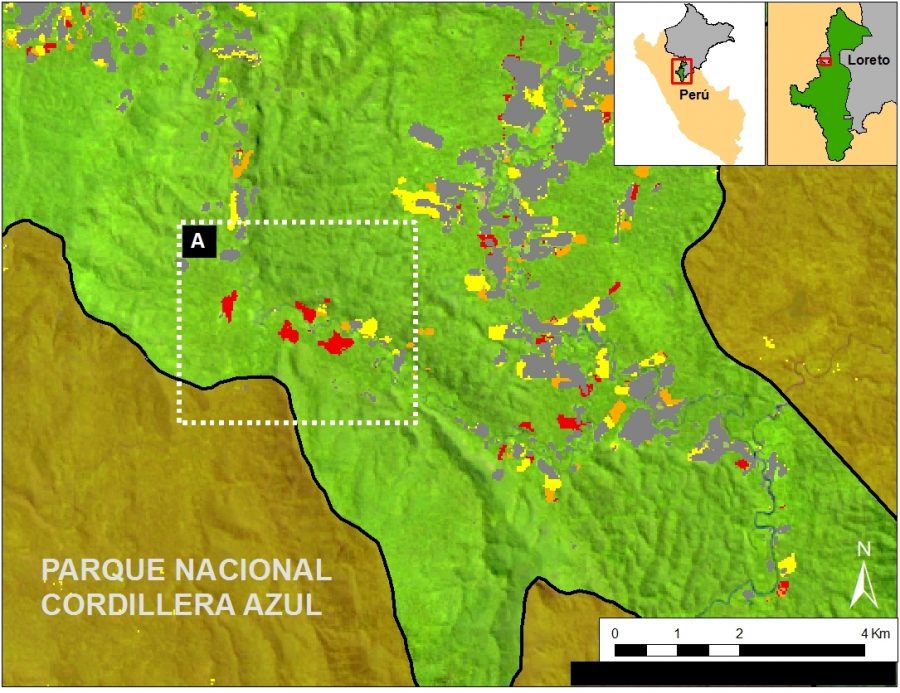 Image 40g. Data: SERNANP, Landsat, UMD/GLAD, Hansen/UMD/Google/USGS/NASA
Image 40h shows high-resolution images of the area indicated by Inset A between December 2015 (left panel), January 2016 (central panel), and July 2016 (right panel). The yellow circles indicate areas that were deforested between these dates. The driver of the deforestation appears to be establishlisment of small-scale agricultural plantations.
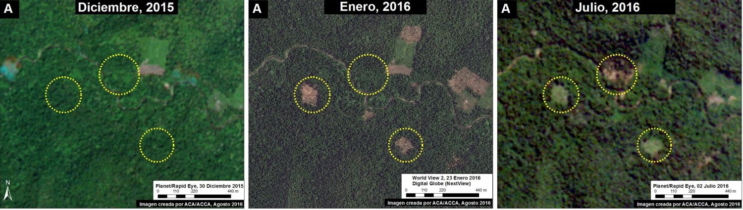 Image 40h. Data: RapidEye/Planet, Digital Globe (Nextview)
Citation
Finer M, Novoa S, Gold E (2016) Early Alerts of Deforestation in the Peruvian Amazon. MAAP: 40.
This post originally appeared on MAAP, which is a project of the Amazon Conservation Association (ACA)—a Global Forest Watch Small Grants Fund recipient.
Explore More Articles

Oct 16, 2019|Data and Research|5 minutes
Triumphs and Challenges of Using Deforestation Alerts in Peru
In 2016, Global Forest Watch (GFW) and the University of Maryland released the world’s most detailed satellite-based deforestation alerts. Since the launch, the GLAD alert system has expanded from just three countries to the entire tropical region and is accessed by hundreds of thousands of users through GFW. Peru’s Early Warning Alerts After using the GLAD deforestation alerts, […]

Dec 27, 2017|Data and Research|6 minutes
A Year in Review: Global Forest Watch Highlights from 2017
It’s been another busy year for Global Forest Watch! This year we focused on putting the right data into the hands of our users to support action on the ground. We added more local data and made it easier than ever for decision-makers and on-the-ground forest monitors to access the information they need through national […]
Explore More Articles


