- Data
Early Warning Systems for Deforestation: An Explainer
Jul 30, 2018||7 minutes
Languages
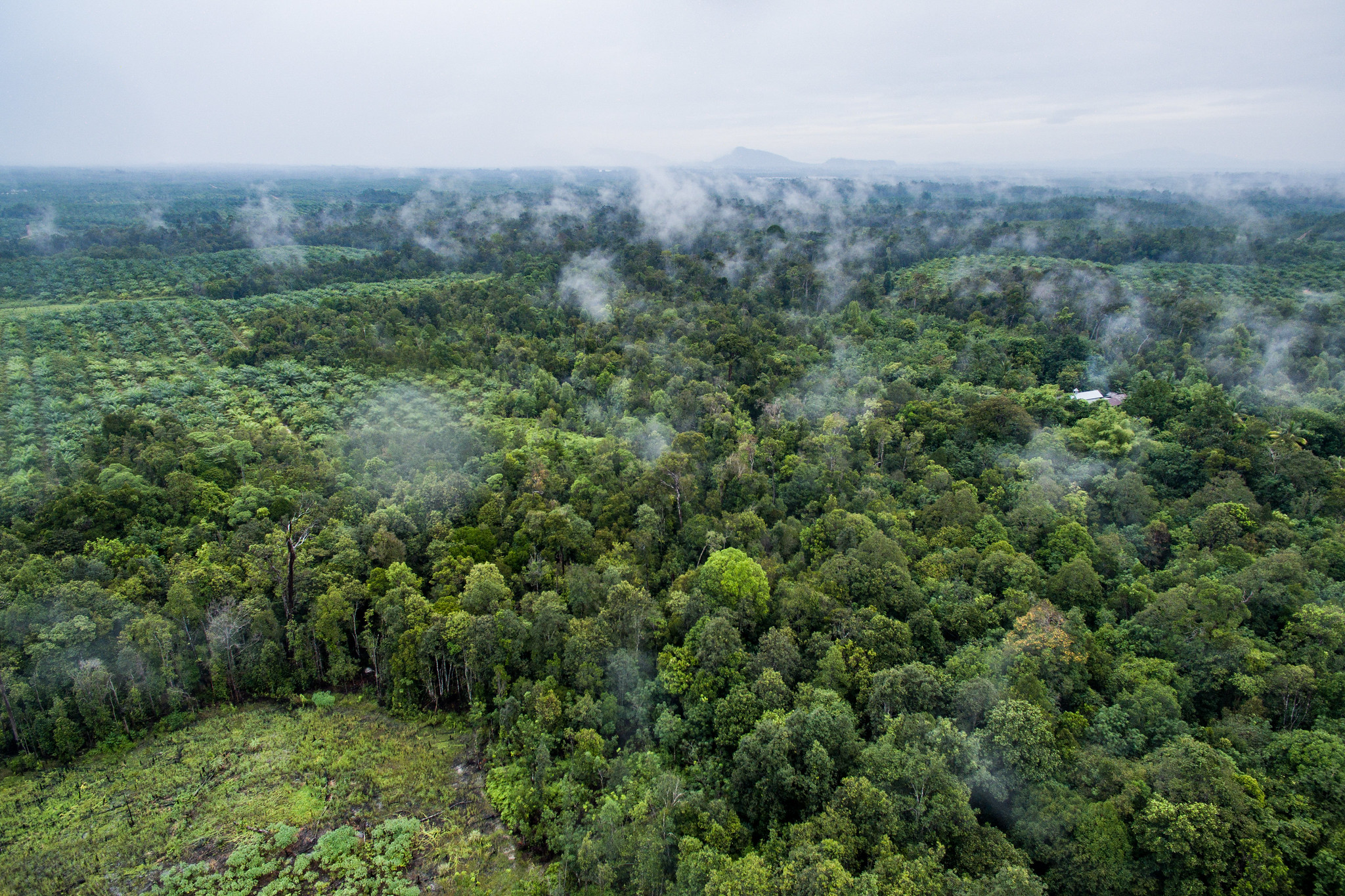
Identifying illegal forest activities using traditional methods such as foot patrols can be time consuming, expensive and often ineffective at stopping clearing before it’s too late. But thanks to recent technological advancements, we can detect forest disturbances more quickly than ever. Authorities can now prioritize areas for investigation and enforcement using satellite data to rapidly identify forest changes.
These systems, known among the forest monitoring community as Early Warning systems, can provide an alarm for illegal and unsustainable activities that might otherwise go unseen. Early Warning systems are designed to identify locations of forest change as quickly as possible, usually on a weekly or monthly basis. While these systems play a valuable role in prioritizing resources allocation for law enforcement and conservation, they are not designed to quantify the amount of change for in-depth reporting or analyses.
Next week, Peru will convene an event bringing together Early Warning users and producers from around the world to share lessons learned from the development and application of these systems. The explainer below provides background on Early Warning systems, how they work, how they can be applied and key challenges to their development and use.
How do Early Warning systems work?
Early Warning systems produce regular updates about where forest change has recently occurred by taking advantage of satellites like Landsat and MODIS, which provide frequent images of the Earth at no cost. Most systems deploy artificial intelligence methods that can automatically detect deforestation and other disturbances in this imagery by “looking” for a sharp drop in image greenness. These algorithms are sometimes run in parallel processing arrangements, also known as cloud computing, that enable analysis of large areas on a continuous basis.
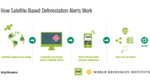
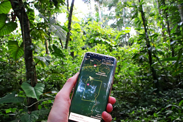
The resulting alerts are then distributed to relevant audiences. Alerts are often displayed on online webmaps like Global Forest Watch or Peru’s Geobosques Platform, emailed to interested parties as bulletins such as through the Amazon Conservation Association’s MAAP, or transmitted to users via mobile devices.
Brazil: The Instituto Nacional de Pesquisas Espaciais (INPE), under the Brazilian Ministry for Science and Technology, developed the first Early Warning system, called DETER, in 2004. Brazil’s environmental enforcement agency uses the data to implement national laws and policies. Some researchers attribute the application of this Early Warning system, along with increased enforcement efforts, to reduced deforestation rates in the Amazon.
Uganda: The Jane Goodall Institute trained monitors at Uganda’s National Forest Authority (NFA) and park rangers with the Uganda Wildlife Authority (UWA) to use weekly forest disturbance alerts to monitor national parks and forests. NFA and UWA staff now use the alerts and other data to prioritize patrols and find and document illegal forest clearing. This has led to prosecutions, fines, and investigations within several critical habitats, including Kibale National Park.
Peru: The Peruvian Ministry of Environment (MINAM) distributes weekly forest disturbance alerts via their online portal Geobosques to over 800 subscribers from government, civil society, and the private sector. The alerts help Peruvian authorities to identify, halt, and prosecute cases of illegal logging and mining. The Peruvian Forest Service (SERFOR) is incorporating Early Warning alerts in the national control and vigilance system (Sistema Nacional de Control y Vigilancia) to support law enforcement actions and coordination across agencies.
The Rainforest Foundation US has trained over 30 communities in the Amazon to use deforestation alerts and mobile phones to monitor and address active threats to their territory. Field data from indigenous patrols is shared with law enforcement to support investigations.
How are Early Warning systems used?
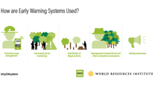
Early Warning systems enable governments, civil society and the private sector to rapidly respond to suspected illegal or unsustainable forest clearing. Applications of Early Warning data include:
- Protected area management: Park rangers can use alerts to support “perimeter defense,” and prioritize resources to investigate clearing.
- Community forest monitoring: Indigenous and local communities can use alerts to quickly identify threats to their territories, understand where forests are being exploited and share information with relevant authorities when appropriate.
- Interdiction of illegal activities: Law enforcement agencies can use the data to prioritize field investigations and implement national policies related to how forests are zoned for protection, or use.
- Management of agricultural and other productive concessions: Agricultural companies with “zero deforestation” commitments can use Early Warning data to flag areas where suppliers may not be complying with company environmental policies.
- Raising awareness: Non-profits and other advocacy groups can use Early Warnings systems to sound alarms around illegal or unsustainable clearing before it moves out of control.
What happens when an alert is triggered?
While the process depends upon who is using the data and for which purpose, researchers have laid out the following general protocol that can lead to action based on Early Warning systems.
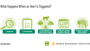
- Detection. Early Warning systems identify areas where forest clearing is likely to have occurred.
- Prioritization. Alerts are overlaid with key geographic boundaries such as protected areas, mining and forest concessions, indigenous territories or ecological data, to determine which alerts may represent illegal activities or activities with a high impact on biodiversity and carbon emissions.
- Identification of drivers and context. The driver of change (e.g. agriculture, road, logging) is identified with high-resolution imagery, drone flights, or field visits in order to understand the needs for subsequent action and the appropriate agencies to involve.
- Effective Communication of Results. Information is shared through online maps, reports, etc., to the relevant audience, whether that is the appropriate government authority, to act upon the information, or the general public, to create pressure on the government to act.
- Impact to Reduce Deforestation. Streamlined coordination between government agencies, ministries or other actors to respond to priority alerts on-the-ground, including issuing fines, making arrests and destroying equipment used to carry out illegal activities.
What systems currently exist?
Several researchers and government agencies have developed systems that provide regular updates to the public.
| NAME | GEOGRAPHIC COVERAGE | FREQUENCY | SPATIAL RESOLUTION | PRODUCED BY | INPUT DATA |
|---|---|---|---|---|---|
| Global and Tropical Systems | |||||
| GLAD alerts | 22 tropical countries | Weekly | 30 meters | University of Maryland | Landsat |
| FORMA | Pantropical | Biweekly | 250 meters | World Resources Institute | MODIS |
| JJ FAST | 77 tropical countries | 1.5 months | 5 hectares | JAXA/JICA | ALOS-2 |
| Terra-i | Pantropical | Monthly | 250 meters | CIAT | MODIS |
| National Systems | |||||
| IDEAM Early Warning Alerts | Colombia | Quarterly | 250 meters | IDEAM (Colombia) | MODIS |
| PNCB Early Warning Alerts | Peruvian Amazon | Weekly | 30 meters | MINAM (Peru) | Landsat |
| DETER-B | Brazilian Amazon | 5 days max | 60 meters | INPE (Brazil) | CBERS-4 and ResourceSat-2 |
What are key challenges for Early Warning systems?
Technical challenges to improving systems utility:
- Cloud coverage: Most of the imagery used to detect change is optical, meaning that much like the human eye, it can’t see through clouds and haze. In some parts of the tropics, clouds prevent the availability of “good” images, sometimes for months at a time. Deforestation could be occurring beneath the clouds, but Early Warning systems can’t “see” it.
- Computational costs of maintaining systems: Automatically processing satellite images on a weekly-to-monthly basis requires significant computing power and costs. These costs will likely increase as systems begin to use higher resolution imagery or produce more rapid updates.
Institutional challenges related to how the information is used by actors responsible for forest management and conservation:
- Uneven adoption across countries: While Early Warning technology has rapidly evolved, adoption of these technologies has been uneven. While some countries, such as Brazil, have utilized Early Warning systems for many years to support implementation of forest laws, other are just beginning to develop these capabilities or adopt existing systems.
- Rapid proliferation of systems outpaces usage: Researchers and private companies are producing new methods and systems, risking confusion over which is best to meet users’ needs. Rapid Early Warning development is outpacing the ability of many government and NGO actors to understand, adopt and apply these systems to forest management challenges.
- Lack of resources to act on Early Warning information: Even where Early Warning systems are in place, agencies or ministries that have jurisdiction to act on the information often lack resources needed for follow up.
- Coordination among government agencies: In many countries, the agency that creates or delivers the Early Warning system is not the same agency that will follow up on the ground. Successfully delivering the data requires trust, cooperation and training among agencies.
How will the Early Warning forum address these challenges?
- Clarify user needs among government, civil society and the private sector.
- Share early lessons by articulating requirements for development, maintenance and promotion of Early Warning data.
- Take stock of available technology solutions, including strengths and limitations, as well as future possibilities.
- Promote effective use of Early Warning systems by enabling multiple stakeholders to exchange knowledge about challenges and best practices for applying Early Warning systems.
Explore More Articles

Explore More Articles


